

Dr. Eng. Abdul Rachman Rasyid, ST., M.Si

| Nip | 197410062008121002 |
|---|---|
| Position | Lektor |
| Areas of Expertise | Penataan Wilayah Kota dan Spasial |
| rachmanrasyid[at]eng[dot]unhas.ac.id |
Penelitian
Pengabdian Masyarakat
Publikasi
- Identifikasi Pola Pemanfaatan Ruang Di Wilayah Pesisir Kabupaten Takalar (2010)
- Arahan Pemanfaatan Ruang Wilayah Pesisir dan Laut Kab. Takalar (2011)
- Mitigasi Bencana Gerakan Tanah Di Kabupaten Enrekang (Mitigation of Vulnerable to Areas Landslide The Regency of Enrekang South Sulawesi Province (2012)
- Use of Frequency Ratio Approach in Landslide Susceptibility Mapping in Jeneberang Watershed of South Sulawesi, Indonesia (2014)
- GIS Based Analysis for Landslide Susceptibility Mapping Using Logistic Regression Model at Lompobattang Mountain, Indonesia (2015)
- Landslide susceptibility mapping using DinSAR and statistic model in Bawakaraeng mountain, Sulawesi, Indonesia (co-authors) (2015)
- Tropical Landslide Susceptibility Mapping using Differential Interferometry SAR and Statistic Model in Bawakaraeng and Lompobattang Mountain, Indonesia (co-authors) (2015)
- Landslide Susceptibility Mapping Using Logistic Regression in Eastern Side of Lompobattang Mountain, Indonesia (2016)
- Weight of Evidence model applied to landslide susceptibility mapping based on GIS in Bawakaraeng Lompobattang Mountain (2016)
- Temporal validation of landslide susceptibility map: a case of Bawakaraeng Lompobattang Mountain in Indonesia (2016)
- Performance of frequency ratio and logistic regression model in creating GIS based landslides susceptibility map at Lompobattang Mountain, Indonesia (2016)
- GIS based landslide susceptibility mapping using artificial neural network (ANN) Model in South Sulawesi Province, Indonesia (2018)
- Implementing landslide susceptibility map at watershed scale of Lompobattang Mountain South Sulawesi, Indonesia (2018)
- The Vulnerable Socioeconomic Conflict on the Gate Community Neighborhood in Makassar (2019)
- Development Direction of Gunung Nona Tourism Area Based on Landslide Mitigation (2019)
- Penyuluhan dan Pendampingan Pemetaan Partisipatif di Kecamatan Anggeraja Kabupaten Enrekang (2019)
- Peningkatan Kualitas Infrastruktur Permukiman Melalui Pemberdayaan Masyarakat Desa/Kelurahan Berbasis Database Digital Keruangan (Spasial) di Kabupaten Wajo (2019)
- The existence of a mangrove ecosystem as nature tourism-based on global warming mitigation in Lakkang island (2019)
- Analysis of Changes in Urban Heat Islands in Gorontalo City Using the Landsat TM8 Imagery (2021)
Latest News
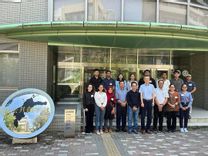 Delegation of the Urban and regional Planning Department took part in the Sakura Science Exchange Program 2023
 2023-08-31T04:05:25.000Z
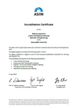 PWK Department received the ASIIN Certificate
 2023-04-11T19:07:10.000Z
 The Prime PWK Masters Study Program Successfully Issued Master's Graduates
 2022-08-25T16:34:11.000Z
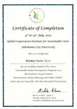 PWK students take part in the Sustainable Urban Development Program Course organized by Yokohama City University (YCU)
 2022-08-11T17:43:10.000Z
 PWK students become the Best Graduates of the Undergraduate Program at the University Level
 2022-07-24T19:50:30.000Z
- more_horiz